It must be remembered that the only constants is that there will always be change, and certainly the this road developed and changed over the seven years we used it. It is remarkable that one old guy I spoke to told me that he had once seen a pride of lions resting under trees at the turn-off. Arusha national Park has no large cats, so that sighting must have been a very long time ago.
And now I see the road is now tar-sealed!
The Ngarenanyuki road leaves the Moshi - Arusha road just East of Usa River but there is no sign to inform, but that is usual! There is a large, concrete godown on the corner which is opposite the large rose farm.
The farm daily exports flowers to Amsterdam and they employ a number of workers who do not benefit from the same health and safety regulations that horticultural workers elsewhere have. I used to go there to buy lucerne hay for Mama Upendo.
I guess every statement deserves an explanation :
The use of insecticide and fungicide without adequate protection is unacceptable but the issues involved were too complex for me to address at the time and this is not the forum either.
The farm encompassed a large are of grass [the roses were grown in tunnel houses] which had been planted in lucerne which was regularly cut and baled. They sold it to specific customers, but would sell to casuals when a surplus was available. Hand cutting fodder for zero grazed cattle is an onerous task and as the season becomes drier, the gathering of fodder is over a much larger area. To help Mama Upendo - and Upendo - I used to buy some of the lucerne hay and from time to time, bundled fodder cut by young men from further up the Ngarenanyuki road or from Usa River.
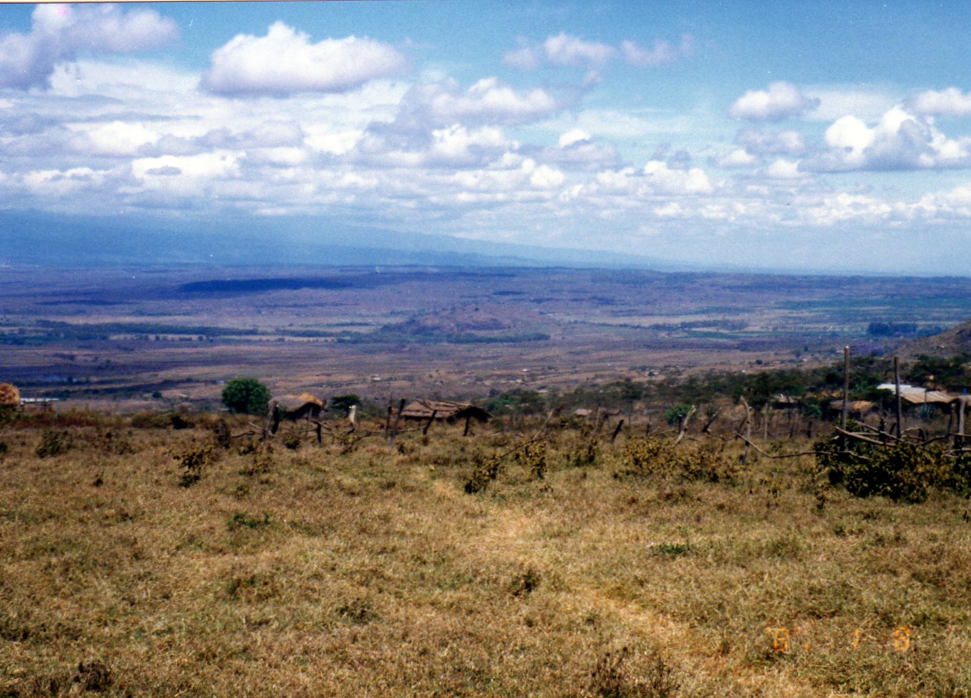
The road starts off long and flat, with rough gravel, through some Silky Oak trees planted each side of the road. Past the new school, International and established to make money, and through fertile farmland. This is where young men cut fodder and transported it on their bikes to Usa River for sale.
There is a ramshackle wooden house where often two men sat to sell a few bananas or other produce and we had an acquaintance that was a twice daily wave as we passed by. We stopped the day we were transporting a sick woman to hospital who needed water and I asked them if the water was clean. They showed me a small, flowing natural spring with fresh, clear water - they were lucky indeed to have it.
To the left there are fertile fields where different cash crops are grown flowers one year, peas another. There is good water here, but during the wet season once the road became impassable and a diversion was made through a large farm. I guess the farmer was not too happy about that. Another time a similar diversion was made because a huge tree fell across the road.
On the corner just before the road climbs uphill, a large, posh safari lodge has been established among what was a very good coffee plantation. Money talks and the owner apparently made his money in the Tanzanite mines - he made it rich and is said to have tossed money from the balcony of the Impala Hotel. At least the story sounds good!
Up the hill there is the homestead of the coffee plantation; obviously well set up and during our stay the built a huge plastic lined reservoir - a huge bank of water should the dam collapse! In the earlier I used to pick a man from Usa River who worked at the plantation - a nice man and I never knew why he never appeared again.
Once this first uphill section has been completed, there is a flat spot where there is a tiny produce market and a road junction that goes to Mt. Meru - actually to Mulala where Mbise lived.
Along on the left a small orphanage was built using burnt bricks - maybe ten children stayed there and over time we had one of those waving relationships which saw us eventually providing a few toys and a little food.
To the left there was a large poultry farm, and again I became aware that I no longer saw people going to and from, so guessed it had closed down, but I never asked and was never told.
Further to the left a new house was built by a Pastor and we helped him with trees, and closeby a sawmill set up business and they committed the unsound practice of spreading sawdust on the road surface.
Again the road climbs, turning as it does so and to the right a family built a burnt brick home so one day we stopped and provided them with trees that were well cared for and flourish - that went on for three seasons.
At Ngongongare there is the Seventh Day Adventist Seminary with its guarded gate and a village beyond complete with dukas and a clinic. Loti lived beyond the village as he has a substantial farm. The guards at the gate knew me and I did not need to sign the entrance book.
Very often people would want a lift down to Usa River and I did not always cooperate as sometimes I needed some space and some quiet. Sometime providing lifts can involve complications.
There is a small market place with some dukas and a research facility for the fluoride in natural water. A few safari lodges, among them Ngurdoto Lodge hosted by friends Dick and Delores Novac - a very nice place to stay!
A little further along is Ngongongare Primary School and beside it a snake park where I saw the biggest chameleons I have ever seen. I'm not sure that it remains open.
To the left is the Lutheran Ailanga Seminary - it was vacant ground when we arrived in Meru and the General Secretary requested ideas from me for its use - I had no input into the suggestion of a seminary. We assisted with tree planting and the rainwater harvesting spouting and tank.
On the other side of the road is the Lutheran Church which was an older, wooden building but by now, I guess there has been some improvements.
This area suffers from wandering elephants, mainly at night, and crops are lost, water projects damaged.
Shortly there is the entrance to Arusha National Park - the road to the left goes to a sawmill where we sourced sawdust, but it closed down, perhaps to reopen.
Nowadays, shortly after the gate is the post where payment is made to enter the park, but previously it was on the right junction of the road a little further on. Sometimes during wet conditions when our usual route was impassable, we took this route and had to negotiate hard for access.
We usua lly took the free, rough route to the left past Little Serengeti where slips once caused the road to become a bog. The road passes through scrublands, climbing all the time, sometimes rocky and rough. It was always ideal to use four wheel drive as it was easier on the vehicle.
Near the summit the vegetation becomes rainforest and there are always Dik Dik, sometimes Colobus Monkeys and often clouds of iridescent blue butterflies.
Once over the small ridge, the rainforest peters out but there are always sitings of warthog with their aerial tails and giraffe and on the roadsides, sometimes there are views of the Ngarenanyuki river as well as indigenous Pencil Juniper trees.
The road heads roughly North and the further you go, the drier the land/vegetation becomes.
The Park exit [or entrance depending where you come from] is where the hikes start their climb of Mt. Meru and where the guides sit and wait for custom - they were usually friendly and waved to us as we 'pita'(ed) by.
The road becomes sharply down hill and the road is of river washed stones - harder to climb. And as the road flattens there has been a cellphone tower erected. Most of this part of the road was dirt with many wet crossings [fords] but the base was hard and there was no danger of becoming bogged or stuck.
This road has now been upgraded.
To the left is t he turnoff to Mwakeny Primary School and to the right Momella, later renamed Nasula Primary School.
Momella is the area where filming took place of the movie 'Hatari' starring John Wayne, Hardy Kruger, Red Buttons to name a few.
After the thicket of yellow-trucked Fever Trees the growing village of Olkung'wado is within site and the turn to the left is now where the local government office is, but past the office is a ford and the road goes on to Kisimiri.
But straight on there is a small bridge which is the entrance to Olkung'wado.
Olkung'wado i s a market town with the 'main street' being a row of dukas. Over the seven years we noticed that this was a growth area - especially houses made from concrete block, causing us to name it the 'grey village'.
Just North of the main village, DME built a new, large clinic and there is their district office and the church, closeby is Olkung'wado Primary School.
It is difficult to find them without some knowledge, but between to village and the DME area there is almost a crossroads; to the right you can reach King'ori via Lendoiya and to the left there is a ford across the river which is a shortcut to Ngarenanyuki village through an area that is wet enough to sustain a banana plantation.
On the 'main road' which by this time becomes more like a track, there is a turnoff to the right which takes you to the village - no, not quite a village - of Emanuel where a new church replaced and old one and where a new primary school was established.
But following the 'main road', after a bend to the left there is the Ngarenanyuki Secondary School, which is also part of the DME fold.
Shortly after there is a bridge that passes over a deep gorge with the Ngarenanyuki River and then a T junction.
To the left is the way to go to Ngabobo and onwards through Maasai country to the North - there was a police post, which became derelict, but because it is possible to reach Kenya on this track, stolen vehicles and contraband used to move through here. There is a junction where the road heads East through Ilkirimuni and on to Sanya Juu.
There is a track that goes off to the right that eventually goes down a long ridge where in our last couple of years, the new Kisomonu was built.
The main road goes on to the small village of Ngarenanyuki, passing on the way, the home of the OiC of the Olkung'wado Clinic, who was a nephew of Loti's making him an associate of mine. Ngarenanyuki is a small market area with a couple of stalls and the road going back to Olkung'wado is to the left and on that road [track] is a small government hospital.
By this time the road is really heading West and passes over another bridge and there is an old signpost bearing the familiar Shell petroleum symbol for years ago an international car rally passed through here.
The road/track begins to peter out to a dusty track and through a gulley where to the right a track goes up to where we took Neema (see another post regarding her).
Onwards past the home of Loti's sister and the track is a dust-bath, there is the Ngarenanyuki Primary School and church, after which the worsening track passes through Uwhiro and on to Kisimiri.
Whi le there is a village named 'Ngarenanyuki' the name refers to the area which is huge and we worked throughout the area over the years.
Over the years we carried out a lot of work in the area which will be detailed as time goes on

And now I see the road is now tar-sealed!
The Ngarenanyuki road leaves the Moshi - Arusha road just East of Usa River but there is no sign to inform, but that is usual! There is a large, concrete godown on the corner which is opposite the large rose farm.
The farm daily exports flowers to Amsterdam and they employ a number of workers who do not benefit from the same health and safety regulations that horticultural workers elsewhere have. I used to go there to buy lucerne hay for Mama Upendo.
I guess every statement deserves an explanation :
The use of insecticide and fungicide without adequate protection is unacceptable but the issues involved were too complex for me to address at the time and this is not the forum either.
The farm encompassed a large are of grass [the roses were grown in tunnel houses] which had been planted in lucerne which was regularly cut and baled. They sold it to specific customers, but would sell to casuals when a surplus was available. Hand cutting fodder for zero grazed cattle is an onerous task and as the season becomes drier, the gathering of fodder is over a much larger area. To help Mama Upendo - and Upendo - I used to buy some of the lucerne hay and from time to time, bundled fodder cut by young men from further up the Ngarenanyuki road or from Usa River.
The road starts off long and flat, with rough gravel, through some Silky Oak trees planted each side of the road. Past the new school, International and established to make money, and through fertile farmland. This is where young men cut fodder and transported it on their bikes to Usa River for sale.
There is a ramshackle wooden house where often two men sat to sell a few bananas or other produce and we had an acquaintance that was a twice daily wave as we passed by. We stopped the day we were transporting a sick woman to hospital who needed water and I asked them if the water was clean. They showed me a small, flowing natural spring with fresh, clear water - they were lucky indeed to have it.
To the left there are fertile fields where different cash crops are grown flowers one year, peas another. There is good water here, but during the wet season once the road became impassable and a diversion was made through a large farm. I guess the farmer was not too happy about that. Another time a similar diversion was made because a huge tree fell across the road.
On the corner just before the road climbs uphill, a large, posh safari lodge has been established among what was a very good coffee plantation. Money talks and the owner apparently made his money in the Tanzanite mines - he made it rich and is said to have tossed money from the balcony of the Impala Hotel. At least the story sounds good!
Up the hill there is the homestead of the coffee plantation; obviously well set up and during our stay the built a huge plastic lined reservoir - a huge bank of water should the dam collapse! In the earlier I used to pick a man from Usa River who worked at the plantation - a nice man and I never knew why he never appeared again.
Once this first uphill section has been completed, there is a flat spot where there is a tiny produce market and a road junction that goes to Mt. Meru - actually to Mulala where Mbise lived.
Along on the left a small orphanage was built using burnt bricks - maybe ten children stayed there and over time we had one of those waving relationships which saw us eventually providing a few toys and a little food.
To the left there was a large poultry farm, and again I became aware that I no longer saw people going to and from, so guessed it had closed down, but I never asked and was never told.
Further to the left a new house was built by a Pastor and we helped him with trees, and closeby a sawmill set up business and they committed the unsound practice of spreading sawdust on the road surface.
Again the road climbs, turning as it does so and to the right a family built a burnt brick home so one day we stopped and provided them with trees that were well cared for and flourish - that went on for three seasons.
At Ngongongare there is the Seventh Day Adventist Seminary with its guarded gate and a village beyond complete with dukas and a clinic. Loti lived beyond the village as he has a substantial farm. The guards at the gate knew me and I did not need to sign the entrance book.
Very often people would want a lift down to Usa River and I did not always cooperate as sometimes I needed some space and some quiet. Sometime providing lifts can involve complications.
There is a small market place with some dukas and a research facility for the fluoride in natural water. A few safari lodges, among them Ngurdoto Lodge hosted by friends Dick and Delores Novac - a very nice place to stay!
A little further along is Ngongongare Primary School and beside it a snake park where I saw the biggest chameleons I have ever seen. I'm not sure that it remains open.
To the left is the Lutheran Ailanga Seminary - it was vacant ground when we arrived in Meru and the General Secretary requested ideas from me for its use - I had no input into the suggestion of a seminary. We assisted with tree planting and the rainwater harvesting spouting and tank.
On the other side of the road is the Lutheran Church which was an older, wooden building but by now, I guess there has been some improvements.
This area suffers from wandering elephants, mainly at night, and crops are lost, water projects damaged.
Shortly
 there is the entrance to Arusha National Park - the road to the left goes to a sawmill where we sourced sawdust, but it closed down, perhaps to reopen.
Nowadays, shortly after the gate is the post where payment is made to enter the park, but previously it was on the right junction of the road a little further on. Sometimes during wet conditions when our usual route was impassable, we took this route and had to negotiate hard for access.
We usua
 lly took the free, rough route to the left past Little Serengeti where slips once caused the road to become a bog. The road passes through scrublands, climbing all the time, sometimes rocky and rough. It was always ideal to use four wheel drive as it was easier on the vehicle.
Near the summit the vegetation becomes rainforest and there are always Dik Dik, sometimes Colobus Monkeys and often clouds of iridescent blue butterflies.
Once over the small ridge, the rainforest peters out but there are always sitings of warthog with their aerial tails and giraffe and on the roadsides, sometimes there are views of the Ngarenanyuki river as well as indigenous Pencil Juniper trees.
The road heads roughly North and the further you go, the drier the land/vegetation becomes.
The Park exit [or entrance depending where you come from] is where the hikes start their climb of Mt. Meru and where the guides sit and wait for custom - they were usually friendly and waved to us as we 'pita'(ed) by.
The road becomes sharply down hill and the road is of river washed stones - harder to climb. And as the road flattens there has been a cellphone tower erected. Most of this part of the road was dirt with many wet crossings [fords] but the base was hard and there was no danger of becoming bogged or stuck.
This road has now been upgraded.
To the left is t
 he turnoff to Mwakeny Primary School and to the right Momella, later renamed Nasula Primary School.
Momella is the area where filming took place of the movie 'Hatari' starring John Wayne, Hardy Kruger, Red Buttons to name a few.
After the thicket of yellow-trucked Fever Trees the growing village of Olkung'wado is within site and the turn to the left is now where the local government office is, but past the office is a ford and the road goes on to Kisimiri.
But straight on there is a small bridge which is the entrance to Olkung'wado.
Olkung'wado i
 s a market town with the 'main street' being a row of dukas. Over the seven years we noticed that this was a growth area - especially houses made from concrete block, causing us to name it the 'grey village'.
Just North of the main village, DME built a new, large clinic and there is their district office and the church, closeby is Olkung'wado Primary School.
It is difficult to find them without some knowledge, but between to village and the DME area there is almost a crossroads; to the right you can reach King'ori via Lendoiya and to the left there is a ford across the river which is a shortcut to Ngarenanyuki village through an area that is wet enough to sustain a banana plantation.
On the 'main road' which by this time becomes more like a track, there is a turnoff to the right which takes you to the village - no, not quite a village - of Emanuel where a new church replaced and old one and where a new primary school was established.
But following the 'main road', after a bend to the left there is the Ngarenanyuki Secondary School, which is also part of the DME fold.
Shortly after there is a bridge that passes over a deep gorge with the Ngarenanyuki River and then a T junction.
To the left is the way to go to Ngabobo and onwards through Maasai country to the North - there was a police post, which became derelict, but because it is possible to reach Kenya on this track, stolen vehicles and contraband used to move through here. There is a junction where the road heads East through Ilkirimuni and on to Sanya Juu.
There is a track that goes off to the right that eventually goes down a long ridge where in our last couple of years, the new Kisomonu was built.
The main road goes on to the small village of Ngarenanyuki, passing on the way, the home of the OiC of the Olkung'wado Clinic, who was a nephew of Loti's making him an associate of mine. Ngarenanyuki is a small market area with a couple of stalls and the road going back to Olkung'wado is to the left and on that road [track] is a small government hospital.
By this time the road is really heading West and passes over another bridge and there is an old signpost bearing the familiar Shell petroleum symbol for years ago an international car rally passed through here.
The road/track begins to peter out to a dusty track and through a gulley where to the right a track goes up to where we took Neema (see another post regarding her).
Onwards past the home of Loti's sister and the track is a dust-bath, there is the Ngarenanyuki Primary School and church, after which the worsening track passes through Uwhiro and on to Kisimiri.
Whi
 le there is a village named 'Ngarenanyuki' the name refers to the area which is huge and we worked throughout the area over the years.
Over the years we carried out a lot of work in the area which will be detailed as time goes on

Typical is a young child carrying water at Kisimiri

No comments:
Post a Comment